Emissions
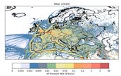
Emissions are a key input for any air quality/chemistry transport model. At TNO, a dedicated team of experts is working on quantification and spatial/temporal distribution of emissions to support air quality and climate modelling, and as input to policy support at national or EU scale.

TNO's emissions team has developed its own spatially resolved emission inventory at high-resolution for the regional (European) scale which is widely used by modelers throughout Europe and beyond. The inventory is based to a large extent on the official country emissions as reported to the EU, the UN Framework Convention on Climate Change (UNFCC), and the UNECE Convention on Long-Range Transboundary Air Pollution.
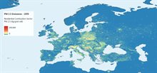
The standard emission inventory contains emissions for key air pollutants such as NOx, SO2, NMVOC, NH3, CO and primary particulate matter (PM2.5 and PM10), and greenhouse gases (CO2, CH4). For details see Kuenen et al. (2022). TNO is the official supplier of the regional emission inventory for the Copernicus Atmospheric Monitoring Service (CAMS). For this purpose the standard inventory is developed further and made available to CAMS at a resolution of 0.1o x 0.05o lon-lat (equivalent to around 6x6 km2 over Europe).

TNO improves upon the standard inventory through scientific development of dedicated emission inventories or descriptions, e.g. for wood burning and road resuspension. Within TOPAS we use these scientific extensions. The most important one is the update of the residential woodcombustion emissions including condensable material as presented by Denier van der Gon et al. (2015).
Current efforts focus (amongst others) on point source emissions and improving temporal resolution of emissions by developing improved time profiles and coupling with actual meteorology (e.g. for emissions from agriculture and from residential combustion).
Natural emissions
Emissions of biogenic volatile organic compounds, sea salt and soil dust are modelled in LOTOS-EUROS using source parametrizations depending on meteorology, vegetation maps, salinity and soil conditions.
Emission estimates emissions of aerosols, chemical species, and greenhouse gases from wild fires are taken on a daily basis from CAMS.